Things to Do in Flores — Waterfalls, Calderas & Fajã Grande
Book an experience
Things to do here
Top-rated activities on this island — book ahead to secure your spot.
Flores is the westernmost island in Europe — the last inhabited land before the Americas. It sits 250km west of the main Azores group, connected to the rest of the archipelago only by small aircraft. The island receives around 3,500 visitors per year — a fraction of São Miguel’s 700,000 — and its infrastructure reflects this. There are no tourist facilities beyond a handful of guesthouses, a few restaurants, and a small car hire operation at the airport.
Flores is for travellers who specifically want remoteness, volcanic landscape at its most dramatic, and an end-of-the-world Atlantic setting. It is not a comfortable island. It rains constantly, the roads are steep, and the ferry connections are limited. The rewards are waterfalls that fall directly into caldera lakes, a coastal village (Fajã Grande) accessible only by one road, and the genuine feeling of being very far from anywhere.
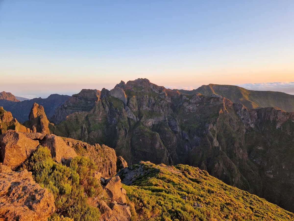
Caldeiras and Caldera Lakes
Flores has seven caldera lakes, more than any other island in the Azores relative to its size. Three are accessible on foot and worth the effort.
Lagoa Funda — the deepest caldera lake on the island (90m), surrounded by basalt walls and subtropical vegetation. The viewpoint (miradouro) above the lake is reached by a marked trail from the road between Santa Cruz das Flores and Caveira. The lake is dark blue-green; the walls of the caldera drop steeply on all sides. Allow 1 hour from the road.
Lagoa Comprida — the longest lake, elongated along a fissure in the volcanic rock. Hydrangeas line the crater edge in summer. The lake sits at 600m elevation; mornings are clearest, the afternoon cloud rolls in from the west.
Caldeira Comprida — a double-crater system with a connecting valley. Less visited than Lagoa Funda but more dramatic in scale. The trail from the trailhead (marked on Google Maps as “Caldeira Comprida viewpoint”) takes 45 minutes one-way.
Waterfalls
Flores’s rainfall feeds a waterfall system that is unlike anything else in the Azores. The island’s western cliffs receive Atlantic storms without interruption from any other landmass; the resulting erosion and flow has created waterfalls that fall directly from clifftops into the sea or into coastal pools.
Poço do Bacalhau — a waterfall that falls 90m into a turquoise pool. The pool is accessible and swimming is possible in calm weather. The path descends steeply from the road, 15 minutes down. The pool is one of the most photographed images of the Azores — the colour of the water against the black rock and green vegetation is exceptional.
Cascata do Ribeiro Grande — on the east coast, a waterfall descending 300m in a series of falls visible from the main road. During and after heavy rain (frequent), the flow is dramatic.
Queda do Veiro — west coast. Accessible from a forest track, this waterfall falls directly onto rocks above the sea. In high swell, the surf and the falling water create a sustained roar. The surrounding vegetation includes Azorean laurel forest, similar to Madeira’s laurissilva.
Fajã Grande
The westernmost village in Europe, built on a ledge of flat land at the base of 500m cliffs on the west coast. One road connects it to the rest of the island; before the road was built in the 1960s, the village was reachable only by boat or on foot over the cliffs.
The village has a church, a handful of houses, and a natural pool below the cliffs that fills with calm seawater when the Atlantic swell permits. From the sea wall, there is open ocean for 6,500km until North America.
The drive from Santa Cruz das Flores (the island capital) to Fajã Grande takes 45 minutes. The road descends the cliff face with switchbacks and passes through forest and waterfall terrain. The village itself is quiet — a few dozen permanent residents and a café that may or may not be open.
Coastal Walks
PR 1 FLW — Rocha dos Bordões — the island’s signature geological formation: a curtain of hexagonal basalt columns, 2–3m across each column, running along a hillside above the sea. The columns formed from cooling lava at a specific rate that produced the hexagonal fracturing pattern. The trail from Santa Cruz runs 6km along the coast before reaching the columns. Allow 3 hours return.
West Coast Walk — no formal waymarked route but the west coast above Fajã Grande is walkable on dirt tracks. The exposure and the cliff views towards the open Atlantic justify the effort.
tours in the Azores cover guided hiking, boat trips, and activity packages — useful for whale watching, caldera walks, and lake tours where local expertise matters.
skip-the-line tickets can be used for bookable attractions including geothermal pools and nature reserves. Pick up an eSIM for Portugal for reliable navigation across the islands.
Practical Realities
Flores requires commitment. Connecting flights are operated by SATA from Faial (40 minutes) and São Miguel (1 hour). They are subject to weather cancellations — Flores’s wind and cloud conditions ground aircraft regularly. Allow a buffer day in your itinerary if you have a fixed onward flight.
Car hire is essential; the island has no useful public transport. Hire from the small operators at Santa Cruz airport (book in advance — the fleet is small). Roads are well-maintained tarmac but narrow and steep in the western villages.
Restaurant choice is extremely limited outside Santa Cruz. The guesthouses typically offer dinner on request; confirm this at check-in. Flores is the westernmost stop in the Azores island hopping itinerary. For where to sleep, see best hotels in Flores and the Flores island guide.
Frequently Asked Questions
- How do I get to Flores in the Azores?
- Flores (FLW) is reached by connecting flight from Faial or São Miguel. There are no direct flights from Lisbon. SATA operates the inter-island routes; journey time from Faial is 40 minutes. Flores is also a stopping point for transatlantic sailing yachts approaching from the west.
- How many people live on Flores?
- Approximately 3,500, spread across eight parishes. The population has declined significantly since the mid-20th century due to emigration to mainland Portugal and the United States.
- Is Flores the rainiest island in the Azores?
- Yes. Flores receives more than 300 days of rain per year on average — more than any other island in the archipelago. This is why the waterfalls, lakes, and vegetation are so dramatic. Visitors should pack for rain regardless of the season.
Tickets & Attractions
Book Experiences in Advance
Pre-book popular attractions, tours, and experiences via Tiqets — instant confirmation and mobile tickets. Skip the queue on busy days.
Browse on Tiqets →Best price guaranteed — same price as booking direct. We earn a small commission at no extra cost to you.
Ready to explore?
Browse hundreds of tours and activities. Book securely with free cancellation on most options.
Browse on GetYourGuide →Best price guaranteed — same price as booking direct. We earn a small commission at no extra cost to you.